lunes, 7 de diciembre de 2020

LIDAR sheds new light on plant phenomics for plant breeding and management: Recent advances and future prospects


Plant phenomics is a new avenue for linking plant genomics and environmental studies, thereby improving plant breeding and management. Remote sensing techniques have improved high-throughput plant phenotyping. However, the accuracy, efficiency, and applicability of three-dimensional (3D) phenotyping are still challenging, especially in field environments.

LIDAR (Light Detection And Ranging) provides a powerful new tool for 3D Phenotyping with the rapid development of facilities and algorithms. Numerous efforts have been devoted to studying static and dynamic changes of structural and functional phenotypes using LIDAR in agriculture. These progresses also improve 3D plant modeling across different spatial–temporal scales and disciplines, providing easier and less expensive association with genes and analysis of environmental practices and affords new insights into breeding and management.

Beyond agriculture phenotyping, LIDAR shows great potential in forestry, horticultural, and grass phenotyping. Although LIDAR has resulted in remarkable improvements in plant phenotyping and modeling, the synthetization of LIDAR-based phenotyping for breeding and management has not been fully explored. In this study, the authors identify three main challenges in LIDAR-based phenotyping development: 1) developing low cost, high spatial–temporal, and hyperspectral LIDAR facilities, 2) moving into multi-dimensional phenotyping with an endeavor to generate new algorithms and models, and 3) embracing open source and big data.

Read more:

https://www.sciencedirect.com/science/article/pii/S0924271620303130?dgcid=rss_sd_all

domingo, 6 de diciembre de 2020

Developing a strategy for precise 3D modelling of large-scale scenes for VR


In this work, it is presented a methodology for precise 3D modelling and multi-source geospatial data blending for the purposes of Virtual Reality immersive and interactive experiences. It has been evaluated on the volcanic island of Santorini due to its formidable geological terrain and the interest it poses for scientific and touristic purposes.

The methodology developed here consists of three main steps: Initially, bathymetric and SRTM (Shuttle Radar Topography Mission) data are scaled down to match the smallest resolution of the dataset. Afterwards, the resulted elevations are combined based on the slope of the relief, while considering a buffer area to enforce a smoother terrain. As a final step, the orthophotos are combined with the estimated DTM (Digital Terrain Model) via applying a nearest neighbour matching schema leading to the final terrain background.

In addition to this, both onshore and offshore points-of-interest were modelled via image-based 3D reconstruction and added to the virtual scene. The overall geospatial data that need to be visualized in applications demanding phototextured hyper-realistic models pose a significant challenge. The 3D models are treated via a mesh optimization workflow, suitable for efficient and fast visualization in virtual reality engines, through mesh simplification, physically based rendering texture maps baking, and level-of-details. 

Read more at https://www.int-arch-photogramm-remote-sens-spatial-inf-sci.net/XLIII-B4-2020/567/2020/isprs-archives-XLIII-B4-2020-567-2020.pdf

sábado, 5 de diciembre de 2020

Ventajas de usar UAVs en investigación criminal


Vamos a tratar en este post el uso de UAVs para investigación criminal.

Indudablemente el software de fotogrametría y el escaneo 3D "in situ" ya se está utilizando con éxito para documentar estas escenas, pero los UAVs ofrecen importantes ventajas que vamos a ver a continuación.

1. Recorte de tiempos

Cuando ocurre un crimen, lo mejor para todos es despejar el área lo antes posible, pero la escena debe documentarse primero.

Los instrumentos más frecuentemente usados por los equipos de investigación criminal son el escáner 3D y/o las estaciones totales y/o la fotografía digital, o una combinación de los tres al objeto de recopilar datos y crear la nube de puntos en 3D correspondiente a la escena del crimen.

Sin embargo, estos métodos pueden requerir una gran cantidad de tiempo y personal capacitado, que puede no siempre estar disponible. Por si esto fuera poco, los alrededores de la escena del crimen pueden ofrecer mucha información muy útil, que sólo se percibe desde las alturas.

Para la documentación de un crimen desde una cierta altura y en un amplio area, los UAVs resultan muy útiles porque pueden recorrer fácilmente distancias más grandes a una altitud conveniente para lograr una cobertura más rápida y precisa, permitiendo reducir entre un 60 y un 80% el tiempo requerido para documentar con precisión la escena del crimen.

2. Recorte de costes

Cerrar el paso a un area e investigar una escena criminal, requiere un trabajo humano que conlleva un coste laboral directamente proporcional al tiempo empleado.

Sin embargo, utilizar UAVs como herramienta para la toma de imágenes tiene un coste inversamente proporcional al tiempo empleado y puede resolverse en mucho menos tiempo utilizando planificadores de vuelo automatizado.

Con estos instrumentos, resulta relativamente económico documentar con precisión la escena de un crimen y acelerar el proceso, especialmente en situaciones con restricciones extremas de tiempo, de personal, o de otros equipos alternativos.

Por otra parte, la adquisición de datos en 3D mediante UAVs permite captar datos allí donde no es posible obtenerlos mediante el uso del escaner láser o la estacion total, como por ejemplo cuando existen obstáculos insalvables.

3. Sus resultados constituyen pruebas documentales

En ultima instancia, el objeto de recopilar datos no es otro que aportar evidencias que puedan ser presentadas ante un tribunal.

Muchas veces, la falta de datos por imposibilidad humana de acceder a ciertas areas hace que sea trabajo imposible presentar pruebas que avalen una sospecha, y es por esto que los datos recogidos por un UAV en un solo vuelo, combinados con un adecuado software de fotogrametría, pueden constituir la prueba definitiva para descartar o confirmar un asesinato o un suicidio, así como para confirmar o descartar la culpabilidad de un imputado.


domingo, 29 de noviembre de 2020

Development and Evaluation of a UAV-Photogrammetry System for Precise 3D Environmental Modeling


The specific requirements of UAV-photogrammetry needs particular solutions for system development, which have mostly been ignored or not assessed adequately in recent studies.

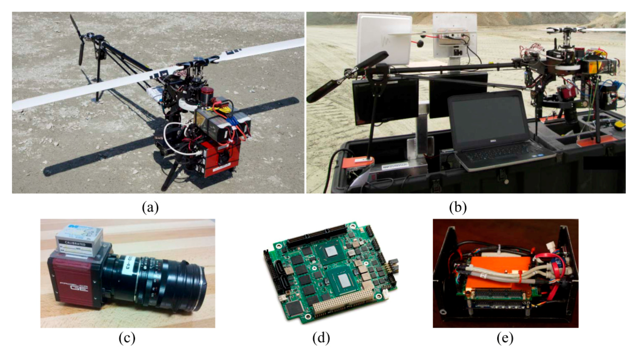
Accordingly, this paper presents the methodological and experimental aspects of correctly implementing an UAV-photogrammetry system. The hardware of the system consists of an electric-powered helicopter, a high-resolution digital camera and an inertial navigation system.

The software of the system includes the in-house programs specifically designed for camera calibration, platform calibration, system integration, on-board data acquisition, flight planning and on-the-job self-calibration. The detailed features of the system are discussed, and solutions are proposed in order to enhance the system and its photogrammetric outputs.

The developed system is extensively tested for precise modeling of the challenging environment of an open-pit gravel mine. The accuracy of the results is evaluated under various mapping conditions, including direct georeferencing and indirect georeferencing with different numbers, distributions and types of ground control points.

Additionally, the effects of imaging configuration and network stability on modeling accuracy are assessed. The experiments demonstrated that 1.55 m horizontal and 3.16 m vertical absolute modeling accuracy could be achieved via direct geo-referencing, which was improved to 0.4 cm and 1.7 cm after indirect geo-referencing.

Read more:

https://www.researchgate.net/publication/283328189_Development_and_Evaluation_of_a_UAV-Photogrammetry_System_for_Precise_3D_Environmental_Modeling

sábado, 28 de noviembre de 2020

Nano Dimension redefine el diseño y fabricación de electrónica para micro-UAVs de uso militar


Cuando nos planteamos el diseño y fabricación de circuitos electrónicos para micro-UAVs de uso militar para operaciones encubiertas, nos encontramos con ciertos retos difíciles o imposibles de superar mediante las tecnologías convencionales de fabricación.

¿Qué podemos hacer cuando el espacio que nos queda para la electrónica, es insuficiente para albergar los circuitos impresos? ¿Sacrificamos prestaciones? ¿Aumentamos el tamaño del micro-UAV? Es un verdadero dilema.

Afortunadamente para los diseñadores y fabricantes de electrónica para uso militar, existe ya la posibilidad de aplicar la manufactura aditiva al diseño y fabricación de circuitos electrónicos.

La tecnología es muy simple, pero han sido necesarios muchos años de investigación hasta conseguir la precisión y repetitividad requeridas para ese tipo de aplicaciones.

Como se estarán imaginando, la tecnología ha sido desarrollada en Israel, en este caso por la firma Nano Dimension (Nasdaq, TASE: NNDM) cuyas máquinas de Impresión 3D para electrónica trabajan inyectando materiales dieléctricos y conductivos de manera simultánea, capa a capa, sin limitaciones de geometría.

Lo verán más claro en este vídeo:

https://www.youtube.com/watch?v=P4NFf42b04E&feature=emb_logo

Coastal Mapping using DJI Phantom 4 RTK in Post-Processing Kinematic Mode


Topographic and geomorphological surveys of coastal areas usually require the aerial mapping of long and narrow sections of littoral.

The georeferencing of photogrammetric models is generally based on the signalization and survey of GCPs (Ground Control Points) which are very time-consuming tasks.

Direct georeferencing with high camera location accuracy due to on-board multi-frequency Global Navigation Satellite System (GNSS) receivers can limit the need for GCPs.

Recently, DJI has made available the Phantom 4 Real-Time Kinematic (RTK) (DJI-P4RTK) which combines the versatility and the ease of use of previous DJI Phantom models with the advantages of a multi-frequency on-board GNSS receiver.

In this paper, the authors have investigated the accuracy of both photogrammetric models and Digital Terrain Models (DTMs) generated in Agisoft Metashape from two different image datasets (nadiral and oblique) acquired by a DJI-P4RTK.

Camera locations were computed with the Post-Processing Kinematic (PPK) of the Receiver Independent Exchange Format (RINEX) file recorded by the aircraft during flight missions. A Continuously Operating Reference Station (CORS) located at a 15 km distance from the site was used for this task.

The results highlighted that the oblique dataset produced very similar results, with GCPs (3D RMSE = 0.025 m) and without (3D RMSE = 0.028 m), while the nadiral dataset was affected more by the position and number of the GCPs (3D RMSE from 0.034 to 0.075 m).

The introduction of a few oblique images into the nadiral dataset without any GCP improved the vertical accuracy of the model (Up RMSE from 0.052 to 0.025 m) and can represent a solution to speed up the image acquisition of nadiral datasets for PPK with the DJI-P4RTK and no GCPs.

Moreover, the results of this research are compared to those obtained in RTK mode for the same datasets. The novelty of this research is the combination of a multitude of aspects regarding the DJI Phantom 4 RTK aircraft and the subsequent data processing strategies for assessing the quality of photogrammetric models, DTMs, and cross-section profiles.

Read more:

https://www.researchgate.net/publication/340328284_Coastal_Mapping_using_DJI_Phantom_4_RTK_in_Post-Processing_Kinematic_Mode

viernes, 27 de noviembre de 2020

UAVs en la Industria 4.0: Escaneo 3D, Optimización Topológica y Gemelos Digitales para el rediseño de UAVs y su fabricación mediante Manufactura Aditiva


La empresa australiana
Silvertone desarrolla, diseña y fabrica vehículos aéreos no tripulados con capacidades de carga útil flexible.

Uno de sus sistemas de aviones no tripulados, el Flamingo Mk3, lleva un paquete pesado de equipos de telemetría y sensores.

Para mejorar la eficiencia del vuelo, el soporte que une el paquete de equipos al fuselaje y soporta el tren de aterrizaje, debía rediseñarse para reducir el peso pero conservando a su vez el rendimiento mecánico.

El diseño existente fue sometido a procesos de optimización topológica hasta obtener un diseño orgánico de forma libre que satisfacía las condiciones de carga y de contorno requeridas.

La geometría resultante de la optimización topológica generalmente no se adapta bien a los métodos de fabricación tradicionales. Sin embargo, la fabricación aditiva produce componentes a través de capas y no ofrece limitación alguna a la hora de fabricar una geometría por compleja que sea.

Se contrató a Amiga Engineering para fabricar el componente de topología optimizada. La muestra se imprimió en titanio Gr23 en una máquina ProX DMP de 3D Systems. El componente fabricado logró una reducción de peso significativa: 800 gramos menos que los 4 kilogramos originales, mejor equilibrio y rigidez, mayor seguridad, tiempos de vuelo más largos, mayor capacidad de carga útil y mejor eficiencia de la batería.

Se contrató al proveedor de servicios de metrología Scan-Xpress para medir el componente fabricado utilizando el escáner GOM ATOS Q de alta resolución y para realizar comprobaciones críticas de control de calidad antes de la instalación. El sistema de medición óptica ATOS Q de GOM es muy adecuado para medir superficies orgánicas y de forma libre generadas a partir de la optimización de la topología, incluido el soporte del paquete.

El sensor ATOS Q proyecta una trama de franjas que van cambiando de fase a medida que recorren la superficie de medición, al objeto de recolectar millones de puntos y generar un modelo tridimensional preciso. El sensor fue colocado en diferentes posiciones alrededor del componente hasta que toda la superficie se definió y capturó con precisión. Con la nube de puntos generada se creó una malla 3D en formato STL, conocida como gemelo digital. El gemelo digital generado se comparó con el modelo CAD y se registraron las diferencias.

La información capturada brindó a Amiga Engineering la capacidad de validar sus métodos de producción y simulaciones. Los datos capturados también proporcionaron información para modificar los parámetros del proceso de Manufactura Aditiva para futuras ejecuciones de producción. Esta retroalimentación proporcionada por la calidad de los datos generados fue un factor determinante para que Amiga Engineering comprara el primer ATOS Q de Australia.