domingo, 29 de noviembre de 2020

Development and Evaluation of a UAV-Photogrammetry System for Precise 3D Environmental Modeling


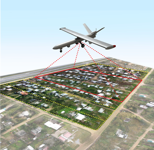
The specific requirements of UAV-photogrammetry needs particular solutions for system development, which have mostly been ignored or not assessed adequately in recent studies.

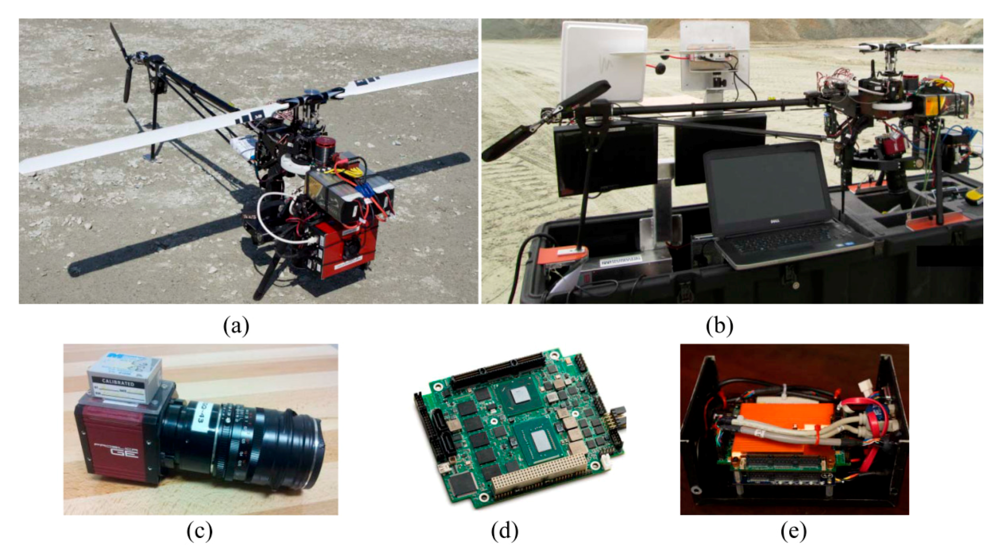
Accordingly, this paper presents the methodological and experimental aspects of correctly implementing an UAV-photogrammetry system. The hardware of the system consists of an electric-powered helicopter, a high-resolution digital camera and an inertial navigation system.

The software of the system includes the in-house programs specifically designed for camera calibration, platform calibration, system integration, on-board data acquisition, flight planning and on-the-job self-calibration. The detailed features of the system are discussed, and solutions are proposed in order to enhance the system and its photogrammetric outputs.

The developed system is extensively tested for precise modeling of the challenging environment of an open-pit gravel mine. The accuracy of the results is evaluated under various mapping conditions, including direct georeferencing and indirect georeferencing with different numbers, distributions and types of ground control points.

Additionally, the effects of imaging configuration and network stability on modeling accuracy are assessed. The experiments demonstrated that 1.55 m horizontal and 3.16 m vertical absolute modeling accuracy could be achieved via direct geo-referencing, which was improved to 0.4 cm and 1.7 cm after indirect geo-referencing.

Read more:

https://www.researchgate.net/publication/283328189_Development_and_Evaluation_of_a_UAV-Photogrammetry_System_for_Precise_3D_Environmental_Modeling

sábado, 28 de noviembre de 2020

Nano Dimension redefine el diseño y fabricación de electrónica para micro-UAVs de uso militar


Cuando nos planteamos el diseño y fabricación de circuitos electrónicos para micro-UAVs de uso militar para operaciones encubiertas, nos encontramos con ciertos retos difíciles o imposibles de superar mediante las tecnologías convencionales de fabricación.

¿Qué podemos hacer cuando el espacio que nos queda para la electrónica, es insuficiente para albergar los circuitos impresos? ¿Sacrificamos prestaciones? ¿Aumentamos el tamaño del micro-UAV? Es un verdadero dilema.

Afortunadamente para los diseñadores y fabricantes de electrónica para uso militar, existe ya la posibilidad de aplicar la manufactura aditiva al diseño y fabricación de circuitos electrónicos.

La tecnología es muy simple, pero han sido necesarios muchos años de investigación hasta conseguir la precisión y repetitividad requeridas para ese tipo de aplicaciones.

Como se estarán imaginando, la tecnología ha sido desarrollada en Israel, en este caso por la firma Nano Dimension (Nasdaq, TASE: NNDM) cuyas máquinas de Impresión 3D para electrónica trabajan inyectando materiales dieléctricos y conductivos de manera simultánea, capa a capa, sin limitaciones de geometría.

Lo verán más claro en este vídeo:

https://www.youtube.com/watch?v=P4NFf42b04E&feature=emb_logo

Coastal Mapping using DJI Phantom 4 RTK in Post-Processing Kinematic Mode


Topographic and geomorphological surveys of coastal areas usually require the aerial mapping of long and narrow sections of littoral.

The georeferencing of photogrammetric models is generally based on the signalization and survey of GCPs (Ground Control Points) which are very time-consuming tasks.

Direct georeferencing with high camera location accuracy due to on-board multi-frequency Global Navigation Satellite System (GNSS) receivers can limit the need for GCPs.

Recently, DJI has made available the Phantom 4 Real-Time Kinematic (RTK) (DJI-P4RTK) which combines the versatility and the ease of use of previous DJI Phantom models with the advantages of a multi-frequency on-board GNSS receiver.

In this paper, the authors have investigated the accuracy of both photogrammetric models and Digital Terrain Models (DTMs) generated in Agisoft Metashape from two different image datasets (nadiral and oblique) acquired by a DJI-P4RTK.

Camera locations were computed with the Post-Processing Kinematic (PPK) of the Receiver Independent Exchange Format (RINEX) file recorded by the aircraft during flight missions. A Continuously Operating Reference Station (CORS) located at a 15 km distance from the site was used for this task.

The results highlighted that the oblique dataset produced very similar results, with GCPs (3D RMSE = 0.025 m) and without (3D RMSE = 0.028 m), while the nadiral dataset was affected more by the position and number of the GCPs (3D RMSE from 0.034 to 0.075 m).

The introduction of a few oblique images into the nadiral dataset without any GCP improved the vertical accuracy of the model (Up RMSE from 0.052 to 0.025 m) and can represent a solution to speed up the image acquisition of nadiral datasets for PPK with the DJI-P4RTK and no GCPs.

Moreover, the results of this research are compared to those obtained in RTK mode for the same datasets. The novelty of this research is the combination of a multitude of aspects regarding the DJI Phantom 4 RTK aircraft and the subsequent data processing strategies for assessing the quality of photogrammetric models, DTMs, and cross-section profiles.

Read more:

https://www.researchgate.net/publication/340328284_Coastal_Mapping_using_DJI_Phantom_4_RTK_in_Post-Processing_Kinematic_Mode

viernes, 27 de noviembre de 2020

UAVs en la Industria 4.0: Escaneo 3D, Optimización Topológica y Gemelos Digitales para el rediseño de UAVs y su fabricación mediante Manufactura Aditiva


La empresa australiana
Silvertone desarrolla, diseña y fabrica vehículos aéreos no tripulados con capacidades de carga útil flexible.

Uno de sus sistemas de aviones no tripulados, el Flamingo Mk3, lleva un paquete pesado de equipos de telemetría y sensores.

Para mejorar la eficiencia del vuelo, el soporte que une el paquete de equipos al fuselaje y soporta el tren de aterrizaje, debía rediseñarse para reducir el peso pero conservando a su vez el rendimiento mecánico.

El diseño existente fue sometido a procesos de optimización topológica hasta obtener un diseño orgánico de forma libre que satisfacía las condiciones de carga y de contorno requeridas.

La geometría resultante de la optimización topológica generalmente no se adapta bien a los métodos de fabricación tradicionales. Sin embargo, la fabricación aditiva produce componentes a través de capas y no ofrece limitación alguna a la hora de fabricar una geometría por compleja que sea.

Se contrató a Amiga Engineering para fabricar el componente de topología optimizada. La muestra se imprimió en titanio Gr23 en una máquina ProX DMP de 3D Systems. El componente fabricado logró una reducción de peso significativa: 800 gramos menos que los 4 kilogramos originales, mejor equilibrio y rigidez, mayor seguridad, tiempos de vuelo más largos, mayor capacidad de carga útil y mejor eficiencia de la batería.

Se contrató al proveedor de servicios de metrología Scan-Xpress para medir el componente fabricado utilizando el escáner GOM ATOS Q de alta resolución y para realizar comprobaciones críticas de control de calidad antes de la instalación. El sistema de medición óptica ATOS Q de GOM es muy adecuado para medir superficies orgánicas y de forma libre generadas a partir de la optimización de la topología, incluido el soporte del paquete.

El sensor ATOS Q proyecta una trama de franjas que van cambiando de fase a medida que recorren la superficie de medición, al objeto de recolectar millones de puntos y generar un modelo tridimensional preciso. El sensor fue colocado en diferentes posiciones alrededor del componente hasta que toda la superficie se definió y capturó con precisión. Con la nube de puntos generada se creó una malla 3D en formato STL, conocida como gemelo digital. El gemelo digital generado se comparó con el modelo CAD y se registraron las diferencias.

La información capturada brindó a Amiga Engineering la capacidad de validar sus métodos de producción y simulaciones. Los datos capturados también proporcionaron información para modificar los parámetros del proceso de Manufactura Aditiva para futuras ejecuciones de producción. Esta retroalimentación proporcionada por la calidad de los datos generados fue un factor determinante para que Amiga Engineering comprara el primer ATOS Q de Australia.

domingo, 22 de noviembre de 2020

Impresión 3D para camuflar puntos de acceso IoT/WiFi en nano-UAVs


Los usuarios y los fabricantes de nano-UAVs están viendose constantemente impulsados ​​a demandar y agregar nuevas capacidades al producto final, y entre esas capacidades merecen destacarse todas aquellas relacionadas con el IoT (Internet of Things).

La firma israelí Nano Dimension Ltd. ha demostrado que es posible fabricar dispositivos de comunicación IoT/WiFi impresos en 3D para que los OEMs de nano-UAVs puedan añadirlos a su producto final.

La velocidad de fabricación distingue a estos nuevos dispositivos, ya que Nano Dimension afirma que pueden estar listos para funcionar en sólo 18 horas, lo que equivale a una velocidad de producción un 90 por ciento más rápida que utilizando métodos convencionales.

Más información:

https://www.nano-di.com/capabilities-and-use-cases

Digital Innovations in European Archaeology


European archaeologists in the last two decades have worked to integrate a wide range of emerging digital tools to enhance the recording, analysis, and dissemination of archaeological data.

These techniques have expanded and altered the data collected by archaeologists as well as their interpretations. At the same time archaeologists have expanded the capabilities of using these data on a large scale, across platforms, regions, and time periods, utilising new and existing digital research infrastructures to enhance the scale of data used for archaeological interpretations.

This Element discusses some of the most recent, innovative uses of these techniques in European archaeology at different stages of archaeological work. In addition to providing an overview of some of these techniques, it critically assesses these approaches and outlines the recent challenges to the discipline posed by self-reflexive use of these tools and advocacy for their open use in cultural heritage preservation and public engagement.

Among these techniques used frequently in various archaeological contexts across Europe, aerial photogrammetry, utilising photographs taken by UAVs (Unmanned Aerial Vehicles) has been used to document larger landscapes and close-range photogrammetry is becoming a ubiquitous recording tool on excavations and for historic architectural recording. The low financial entry point to photogrammetry has made it an ideal technique for archaeologists, who are often working on a shoe-string budget.

Most archaeological projects are already equipped with a digital SLR (Single Lens Reflex) camera and most of the necessary software licenses for image processing are open access or available at steeply reduced educational discounts.

Read more: https://www.cambridge.org/core/elements/digital-innovations-in-european-archaeology/BDEA933427350E7D500F773A31EC9F4B/core-reader

sábado, 21 de noviembre de 2020

Impresión 3D para circuitos electrónicos alojados en nano-UAVs


Durante los últimos años, los nano-UAVs han venido siendo utilizados como un instrumento clave en operaciones encubiertas llevadas a cabo por la CIA, el FBI, el M16, el Mosad, la Sayeret Matkal así como otros grupos de inteligencia de diversos países.

Lo ideal para misiones ISR sería contar con un instrumento dotado de un conjunto de sensores capaces de llevar a cabo la misión permitiendo al operario ver mediante cámaras multiespectro, escuchar todo tipo de sonidos dentro y fuera del rango 20Hz-20KHz, e incluso detectar la presencia de explosivos, isótopos radioactivos, gases tóxicos, etc.

Por supuesto, ese instrumento debería estar diseñado para no ser detectado a simple vista por un humano, pasando desapercibido como un insecto. Ok, ¿Y qué más? Porque todo eso requiere diseñar circuitos electrónicos muy complejos, que deben ser alojados en volúmenes muy reducidos de geometría muy compleja, y ante ese tipo de situaciones, el diseño y fabricación convencionales de circuitos electrónicos no sirve.

Se hacía necesario pensar otra manera de fabricar, y otra manera de diseñar. Afortunadamente esta nueva manera de fabricar ya está disponible no sólo para uso militar sino también para uso civil, y sus siglas son AME que corresponden a Additive Manufacturing for Electronics. Una tecnología extraordinaria desarrollada en Israel por ingenieros de la firma Nano Dimension. ¿Se imaginan diseñar circuitos electrónicos no sólo en XY, sino también en Z? ¿Se imaginan poder ocultar componentes electrónicos en el interior de una PCB? ¿Y si la PCB pudiera tener cualquier geometría en los tres ejes?

Es increíble hasta dónde puede llegar esta tecnología. Les invito a descubrirlo a través de este vídeo:


Accuracy assessment of RTK-GNSS equipped UAV conducted as-built surveys for construction site modelling


Regular as-built surveys have become a necessary input for building information modelling.

Such large-scale 3D data capturing can be conducted effectively by combining structure-from-motion and UAVs (Unmanned Aerial Vehicles).

Using a RTK-GNSS (Real Time Kinematic-Global Navigation Satellite Systemequipped UAV, 22 repeated weekly campaigns were conducted at two altitudes in various conditions.

The photogrammetric approach yielded 3D models, which were compared to the terrestrial laser scanning based ground truth. Better than 2.8 cm geometry RMSE (Root Mean Square Error) was consistently achieved using integrated georeferencing.

It is concluded that the RTK-GNSS based georeferencing enables reaching better than 5 cm geometry accuracy by utilising at least one ground control point.

Read more at:

https://www.tandfonline.com/doi/abs/10.1080/00396265.2020.1830544


domingo, 15 de noviembre de 2020

Nano Dimension: Assure Your Electronics Projects Confidentiality


The Nano Dimension’s DragonFly™ Pro Additive Manufacturing Platform for Electronics, is the one-stop solution for creating high-quality 3D Printed electronics confidentially.

The system can 3D print using metals and dielectric polymers simultaneously, allowing for the manufacture of non-planar electronics, antennas, RFIDs, multilayer PCBs, Complex Geometry PCBs, and many other components.

Discover it at:

https://www.youtube.com/watch?v=MDfSrb7FQ7w


Aspen detection in boreal forests: Capturing a key component of biodiversity using airborne hyperspectral, lidar, and UAV data

Importance of biodiversity is increasingly highlighted as an essential part of sustainable forest management.

As direct monitoring of biodiversity is not possible, proxy variables have been used to indicate site's species richness and quality. In boreal forests, European aspen (Populus tremula L.) is one of the most significant proxies for biodiversity.

Aspen is a keystone species, hosting a range of endangered species, hence having a high importance in maintaining forest biodiversity. Still, reliable and fine-scale spatial data on aspen occurrence remains scarce and incomprehensive. Although remote sensing-based species classification has been used for decades for the needs of forestry, commercially less significant species (e.g., aspen) have typically been excluded from the studies.

This creates a need for developing general methods for tree species classification covering also ecologically significant species. Our study area, located in Evo, Southern Finland, covers approximately 83 km2, and contains both managed and protected southern boreal forests. The main tree species in the area are Scots pine (Pinus sylvestris L.), Norway spruce (Picea abies (L.) Karst), and birch (Betula pendula and pubescens L.), with relatively sparse and scattered occurrence of aspen.

Along with a thorough field data, airborne hyperspectral and LiDAR data have been acquired from the study area. We also collected ultra high resolution UAV data with RGB and multispectral sensors. The aim is to gather fundamental data on hyperspectral and multispectral species classification, that can be utilized to produce detailed aspen data at large scale. For this, we first analyze species detection at tree-level. We test and compare different machine learning methods (Support Vector Machines, Random Forest, Gradient Boosting Machine) and deep learning methods (3D Convolutional Neural Networks), with specific emphasis on accurate and feasible aspen detection.

The results will show, how accurately aspen can be detected from the forest canopy, and which bandwidths have the largest importance for aspen. This information can be utilized for aspen detection from satellite images at large scale.

Read more at https://ui.adsabs.harvard.edu/abs/2020EGUGA..2221268K/abstract

sábado, 14 de noviembre de 2020

Deep Learning Classification of 2D Orthomosaic Images and 3D Point Clouds for Post-Event Structural Damage Assessment


Efficient and rapid data collection techniques are necessary to obtain transitory information in the aftermath of natural hazards, which is not only useful for post-event management and planning, but also for post-event structural damage assessment.

Aerial imaging from UAVs permits highly detailed site characterization, in particular in the aftermath of extreme events with minimal ground support, to document current conditions of the region of interest. However, aerial imaging results in a massive amount of data in the form of two-dimensional (2D) orthomosaic images and three-dimensional (3D) point clouds.

Both types of datasets require effective and efficient data processing workflows to identify various damage states of structures. This manuscript aims to introduce two deep learning models based on both 2D and 3D convolutional neural networks to process the orthomosaic images and point clouds, for post windstorm classification.

In detail, 2D CNN (2D Convolutional Neural Networks) are developed based on transfer learning from two well-known networks AlexNet and VGGNetIn contrast, a 3DFCN (3D Fully Convolutional Network) with skip connections was developed and trained based on the available point cloud data. Within this study, the datasets were created based on data from the aftermath of Hurricanes Harvey (Texas) and Maria (Puerto Rico). The developed 2DCNN and 3DFCN models were compared quantitatively based on the performance measures, and it was observed that the 3DFCN was more robust in detecting the various classes.

This demonstrates the value and importance of 3D Datasets, particularly the depth information, to distinguish between instances that represent different damage states in structures.

domingo, 8 de noviembre de 2020

Empower innovation in your micro-UAVs with the technology of Nano Dimension


Meet Nano Dimension, a technology company, disrupting, shaping and defining the future of how electronics are made:

https://www.youtube.com/watch?v=P4NFf42b04E&feature=emb_logo

The products and solutions they offer are bridging today's world with the electronics of tomorrow.

Moving the industry, from 2D to 3D, from initial design right through to manufacturing, with the DragonFly  Pro Additive Manufacturing System, the world's first professional 3D printer for electronics, highly conductive silver nanoparticle ink, dielectric ink and advanced 3D software

Learn more about Nano Dimension DragonFly Pro System technology here: https://bit.ly/2LZtbkr

Learn more about additive manufacturing for electronics here: https://bit.ly/2StPkgB

Contact Nano Dimension here: https://bit.ly/2TavMLb

For more information about Nano Dimension, please click here: https://www.nano-di.com

Get the latest news from Nano Dimension: https://bit.ly/2E22Nnv


3D Fire Front Reconstruction in UAV-Based Forest-Fire Monitoring System


This work presents a new method of 3D reconstruction of the forest-fire front based on uncertain observations captured by remote sensing from UAVs within the forest-fire monitoring system.

The use of multiple cameras simultaneously to capture the scene and recognize its geometry including depth is proposed. Multi-directional observation allows perceiving and representing a volumetric nature of the fire front as well as the dynamics of the fire process.

The novelty of the proposed approach lies in the use of soft rough set to represent forest fire model within the discretized hierarchical model of the terrain and the use of 3D CNN (3D Convolutional Neural Network) to classify voxels within the reconstructed scene.

The developed method provides sufficient performance and good visual representation to fulfill the requirements of fire response decision makers. 

Read more at: https://ieeexplore.ieee.org/abstract/document/9204196

lunes, 2 de noviembre de 2020

Method for establishing the UAV-rice vortex 3D model and extracting spatial parameters

With the deepening research on the rotor wind field of UAV operation, it has become a mainstream to quantify the UAV operation effect and study the distribution law of rotor wind field via the spatial parameters of the UAV-rice interaction wind field vortex. 

At present, the point cloud segmentation algorithms involved in most wind field vortex spatial parameter extraction methods cannot adapt to the instantaneous changes and indistinct boundary of the vortex.  As a result, there are problems such as inaccurate three-dimensional (3D) shape and boundary contour of the wind field vortex as well as large errors in the vortex’s spatial parameters. 

To this end, this paper proposes an accurate method for establishing the UAV-rice interaction vortex 3D model and extracting vortex spatial parameters.  Firstly, the original point cloud data of the wind filed vortex were collected in the image acquisition area.  Secondly, DDC-UL processed the original point cloud data to develop the 3D point cloud image of the wind field vortex. 

Thirdly, the 3D curved surface was reconstructed and spatial parameters were then extracted.  Finally, the volume parameters and top surface area parameters of the UAV-rice interaction vortex were calculated and analyzed.  The results show that the error rate of the 3D model of the UAV-rice interaction wind field vortex developed by the proposed method is kept within 2%, which is at least 13 percentage points lower than that of algorithms like PointNet

The average error rates of the volume parameters and the top surface area parameters extracted by the proposed method are 1.4% and 4.12%, respectively.  This method provides 3D data for studying the mechanism of rotor wind field in the crop canopy through the 3D vortex model and its spatial parameters.

Read more at: http://www.ijpaa.org/index.php/ijpaa/article/view/84

domingo, 1 de noviembre de 2020

Federated Learning in the Sky: Aerial-Ground Air Quality Sensing Framework with UAV Swarms


Due to air quality significantly affects human health, it is becoming increasingly important to accurately and timely predict the Air Quality Index (AQI).

To this end, this paper proposes a new federated learning-based aerial-ground air quality sensing framework for fine-grained 3D air quality monitoring and forecasting.

Specifically, in the air, this framework leverages a light-weight Dense-MobileNet model to achieve energy-efficient end-to-end learning from haze features of haze images taken by UAVs (Unmanned Aerial Vehicles) for predicting AQI scale distribution.

Furthermore, the Federated Learning Framework not only allows various organizations or institutions to collaboratively learn a well-trained global model to monitor AQI without compromising privacy, but also expands the scope of UAV swarms monitoring.

For ground sensing systems, it is proposed a GC-LSTM (Graph Convolutional neural network-based Long Short-Term Memory) model to achieve accurate, real-time and future AQI inference. The GC-LSTM model utilizes the topological structure of the ground monitoring station to capture the spatio-temporal correlation of historical observation data, which helps the aerial-ground sensing system to achieve accurate AQI inference.

Through extensive case studies on a real-world dataset, numerical results show that the proposed framework can achieve accurate and energy-efficient AQI sensing without compromising the privacy of raw data.

Read more: https://ieeexplore.ieee.org/abstract/document/9184079